Beerenberg
{{Infobox mountain | name = Beerenberg | image = Beerenberg Jan Mayen.JPG | image_caption = Beerenberg, July 2011 | elevation_m = 2277 | elevation_ref = | prominence_m = 2277 | prominence_ref = | listing = Ultra | pushpin_map = North…
≈ 5 min read
Names in other languages
No names in other languages are held for this entry yet.
Article bodies are English and are not machine-translated. A name in another language is not a translation of the article.
{{Infobox mountain | name = Beerenberg | image = Beerenberg Jan Mayen.JPG | image_caption = Beerenberg, July 2011 | elevation_m = 2277 | elevation_ref = | prominence_m = 2277 | prominence_ref = | listing = Ultra | pushpin_map = North Atlantic | map_alt = | map_caption = | map_size = 200 | pushpin_label = Beerenberg | pushpin_label_position = Bottom | coordinates = | translation = | language = Dutch | location = Jan Mayen, Norway | range = | topo_map = | type = Stratovolcano | age = | last_eruption = January 1985 | first_ascent = 1921 Wordie, Mercanton and Lethbridge | easiest_route = | image_map ={{#tag:mapframe|[{ "type": "Feature", "properties": { "marker-size": "small", "marker-color": "#666666", "marker-symbol": "volcano", "title": "Haakon VII Toppen" }, "geometry": {"type": "Point", "coordinates":[-8.1777682,71.0822028]} },{ "type": "Feature", "properties": { "stroke-width":5, "stroke": "#ff0000", "fill": "#ff0000", "stroke-opacity":1.0, "fill-opacity":0.5, "title": "Beerenberg crater ref.…
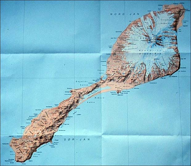
{{Infobox mountain | name = Beerenberg | image = Beerenberg Jan Mayen.JPG | image_caption = Beerenberg, July 2011 | elevation_m = 2277 | elevation_ref = | prominence_m = 2277 | prominence_ref = | listing = Ultra | pushpin_map = North Atlantic | map_alt = | map_caption = | map_size = 200 | pushpin_label = Beerenberg | pushpin_label_position = Bottom | coordinates = | translation = | language = Dutch | location = Jan Mayen, Norway | range = | topo_map = | type = Stratovolcano | age = | last_eruption = January 1985 | first_ascent = 1921 Wordie, Mercanton and Lethbridge | easiest_route = | image_map ={{#tag:mapframe|[{ "type": "Feature", "properties": { "marker-size": "small", "marker-color": "#666666", "marker-symbol": "volcano", "title": "Haakon VII Toppen" }, "geometry": {"type": "Point", "coordinates":[-8.1777682,71.0822028]} },{ "type": "Feature", "properties": { "stroke-width":5, "stroke": "#ff0000", "fill": "#ff0000", "stroke-opacity":1.0, "fill-opacity":0.5, "title": "Beerenberg crater ref. " }, "geometry": { "type": "LineString", "coordinates": [ [-8.1705750,71.0861766],[-8.1710900,71.0856758],[-8.1728066,71.0851750],[-8.1757249,71.0847298],[-8.1769265,71.0836725],[-8.1767549,71.0823925],[-8.1741799,71.0809454],[-8.1721200,71.0798879],[-8.1702317,71.0790530],[-8.1664552,71.0781623],[-8.1630219,71.0774943],[-8.1604470,71.0767150],[-8.1568421,71.0763809],[-8.1535806,71.0757686],[-8.1511773,71.0752397],[-8.1477441,71.0756433],[-8.1453408,71.0763809],[-8.1431092,71.0771603],[-8.1400193,71.0781623],[-8.1377877,71.0792756],[-8.1364144,71.0803889],[-8.1371011,71.0817803],[-8.1372727,71.0828934],[-8.1364144,71.0844516],[-8.1372727,71.0854532],[-8.1377877,71.0864548],[-8.1401910,71.0870669],[-8.1434525,71.0869556],[-8.1429376,71.0879015],[-8.1422509,71.0892924],[-8.1427659,71.0902938],[-8.1453408,71.0909057],[-8.1474008,71.0911282],[-8.1492890,71.0918514],[-8.1511773,71.0923520],[-8.1540955,71.0926302],[-8.1577004,71.0927970] ] } },{ "type": "Feature", "properties": { "stroke-width":1, "stroke": "#ff0000", "fill": "#ff0000", "stroke-opacity":1.0, "fill-opacity":0.5, "title": "Beerenberg crater ref. " }, "geometry": { "type": "Polygon", "coordinates": [ [ [-8.1705750,71.0861766],[-8.1710900,71.0856758],[-8.1728066,71.0851750],[-8.1757249,71.0847298],[-8.1769265,71.0836725],[-8.1767549,71.0823925],[-8.1741799,71.0809454],[-8.1721200,71.0798879],[-8.1702317,71.0790530],[-8.1664552,71.0781623],[-8.1630219,71.0774943],[-8.1604470,71.0767150],[-8.1568421,71.0763809],[-8.1535806,71.0757686],[-8.1511773,71.0752397],[-8.1477441,71.0756433],[-8.1453408,71.0763809],[-8.1431092,71.0771603],[-8.1400193,71.0781623],[-8.1377877,71.0792756],[-8.1364144,71.0803889],[-8.1371011,71.0817803],[-8.1372727,71.0828934],[-8.1364144,71.0844516],[-8.1372727,71.0854532],[-8.1377877,71.0864548],[-8.1401910,71.0870669],[-8.1434525,71.0869556],[-8.1429376,71.0879015],[-8.1422509,71.0892924],[-8.1427659,71.0902938],[-8.1453408,71.0909057],[-8.1474008,71.0911282],[-8.1492890,71.0918514],[-8.1511773,71.0923520],[-8.1540955,71.0926302],[-8.1577004,71.0927970] ] ] } },{ "type": "Feature", "properties": { "marker-size": "small", "marker-color": "#666666", "marker-symbol": "volcano", "title": "Mercantontoppen" }, "geometry": {"type": "Point", "coordinates":[-8.1410439,71.0769555]} },{ "type": "Feature", "properties": { "marker-size": "small", "marker-color": "#964b00", "marker-symbol": "volcano", "title": "Bylandt-Rheidt Crater (OSM Node: 1110344780)" }, "geometry": {"type": "Point", "coordinates":[-8.3036067, 71.0748539]} }] |frameless=1 |align=center |text=Jan Mayen island with Beerenberg crater (red outline) and named peaks (gray) and inactive vent (brown) – click for interactive zoom |width=260 |height=260 |latitude=70.95 |longitude=-8.4 |icon=no |zoom=8 }} | mapframe = no }} Beerenberg is a stratovolcano dominating the northeastern end of the Norwegian island of Jan Mayen. It is high and is the world's northernmost subaerial active volcano and the only active volcano in Norway.
The volcano is topped by a mostly ice-filled crater about wide, with numerous peaks along its rim, including the highest summit, Haakon VII Toppen, on its western side.
See also
List of volcanoes in Norway List of mountains in Norway by prominence
External links
New Jan Mayen Homepage, including general info, photos, blog, and webcam Old Jan Mayen Homepage , including general info, photos, blog, and webcam Beerenberg Expedition 2008 Pictures Pictures and a map of Beerenberg 1970 Beerenberg volcanic eruption captured on film
Text derived from https://en.wikipedia.org/w/index.php?oldid=1375137166 under CC BY-SA 4.0; modifications have been made.