Biddya
≈ 6 min read
Names in other languages
No names in other languages are held for this entry yet.
Article bodies are English and are not machine-translated. A name in another language is not a translation of the article.
Biddya ( ) is a Palestinian city in the Salfit Governorate, located 32 kilometers southwest of Nablus and half that distance from Salfit in the northern West Bank. According to the Palestinian Central Bureau of Statistics (PCBS), Biddya had a population of 10,451 in 2017.
The town is governed by a municipal council of eleven members who each represent the prominent families of Biddya and select a mayor. Biddya is situated on the western ridge of the central mountain range that runs north-south in the West Bank. The historical Nablus-Jerusalem road is nearby.
A maqam (shrine) for a local holy man, Sheikh Hamdan is located in the town.
Biddya ( ) is a Palestinian city in the Salfit Governorate, located 32 kilometers southwest of Nablus and half that distance from Salfit in the northern West Bank. According to the Palestinian Central Bureau of Statistics (PCBS), Biddya had a population of 10,451 in 2017.
The town is governed by a municipal council of eleven members who each represent the prominent families of Biddya and select a mayor. Biddya is situated on the western ridge of the central mountain range that runs north-south in the West Bank. The historical Nablus-Jerusalem road is nearby.
A maqam (shrine) for a local holy man, Sheikh Hamdan is located in the town.
Location
Biddya is located north-west of Salfit. It is bordered by Qarawat Bani Hassan and Sarta to the east, Kafr ad Dik to the south, Sanniriya, Rafat, Az Zawiya and Mas-ha to the west, and Kafr Thulth to the north. It has an elevation of about 359 meters above sea level.
Ottoman era
In 1596, Biddya (also known as Beddia, Bedia, Bidya, Bedya, and Bidieh) appeared in Ottoman tax registers as being in the nahiya of Jabal Qubal in the liwa of Nablus. It had a population of 8 households and 1 bachelor, all Muslim.
The villagers paid a fixed tax-rate of 33.3% on agricultural products, including wheat, barley, summer crops, olive trees, goats and beehives, in addition to occasional revenues; a total of 2,700 akçe. All of the revenue went to a Waqf. In the 18th and 19th centuries, the village formed part of the highland region known as Jūrat ‘Amra or Bilād Jammā‘īn. Situated between Dayr Ghassāna in the south and the present Route 5 in the north, and between Majdal Yābā in the west and Jammā‘īn, Mardā and Kifl Ḥāris in the east, this area served, according to historian Roy Marom, "as a buffer zone between the political-economic-social units of the Jerusalem and the Nablus regions.
On the political level, it suffered from instability due to the migration of the Bedouin tribes and the constant competition among local clans for the right to collect taxes on behalf of the Ottoman authorities." In 1838, Edward Robinson noted it as a village, Bidia, in the Jurat Merda district, south of Nablus.
French explorer Victor Guérin passed by Beddia in 1870, and described it as a "mountain village", apparently of "some importance". In 1870/1871 (1288 AH), an Ottoman census listed the village in the nahiya (sub-district) of Jamma'in al-Thani, subordinate to Nablus. in Biddya]] In the 1882 "Survey of Western Palestine", Bidieh was described as "a village of moderate size, the houses principally of stone.
It is surrounded with beautiful groves of very fine old olives. It is evidently an ancient site. The water supply is from rock-cut cisterns."
British Mandate era
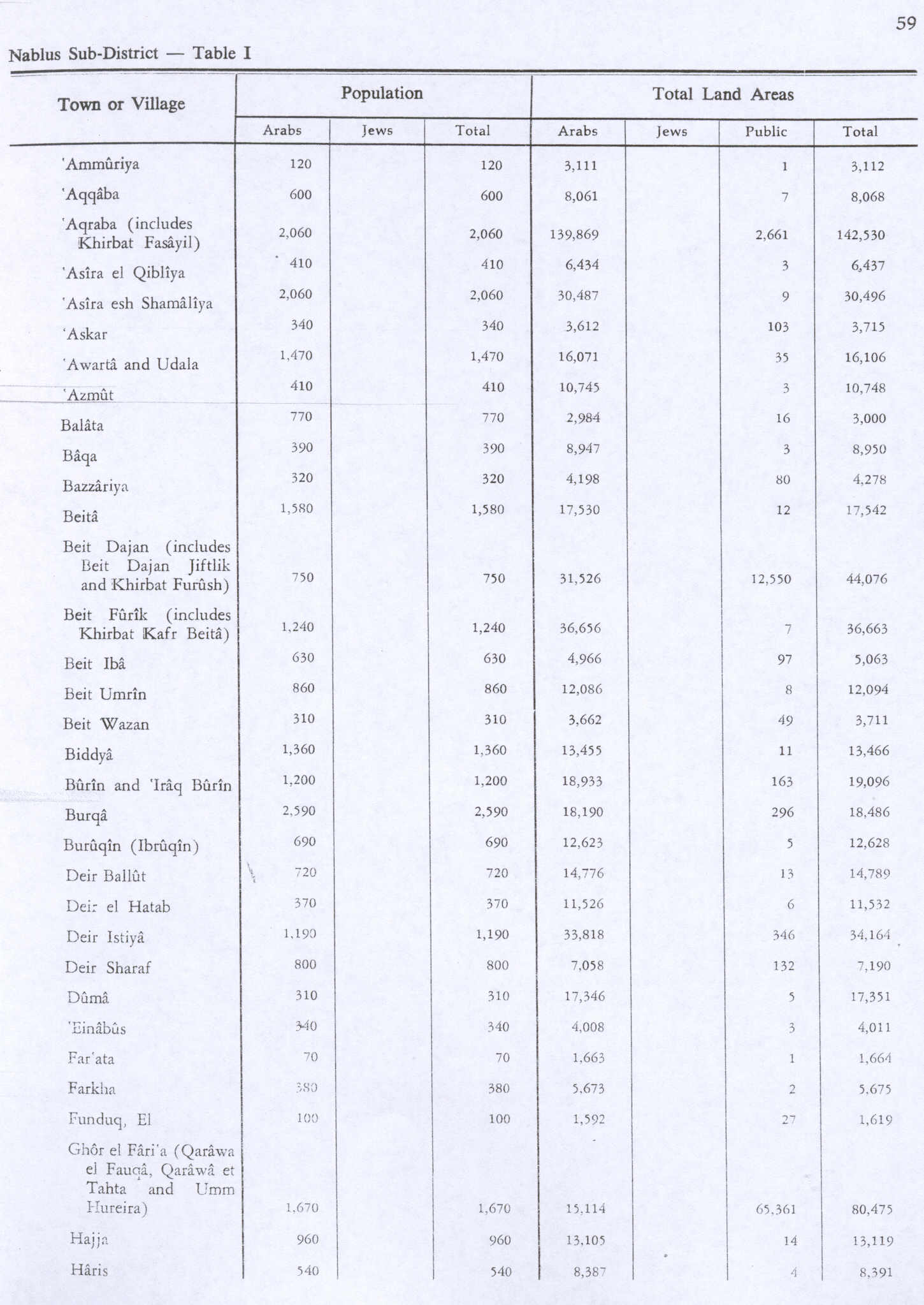
In the 1922 census of Palestine, conducted by the British Mandate authorities, Biddya (called: Bedia) had a population of 792, all Muslims, while in the 1931 census Biddya (including Salita) had 245 occupied houses and a population of 1,026, still all Muslim. In the 1945 statistics the population was 1,360, all Muslims, while the total land area was 13,466 dunams, according to an official land and population survey.
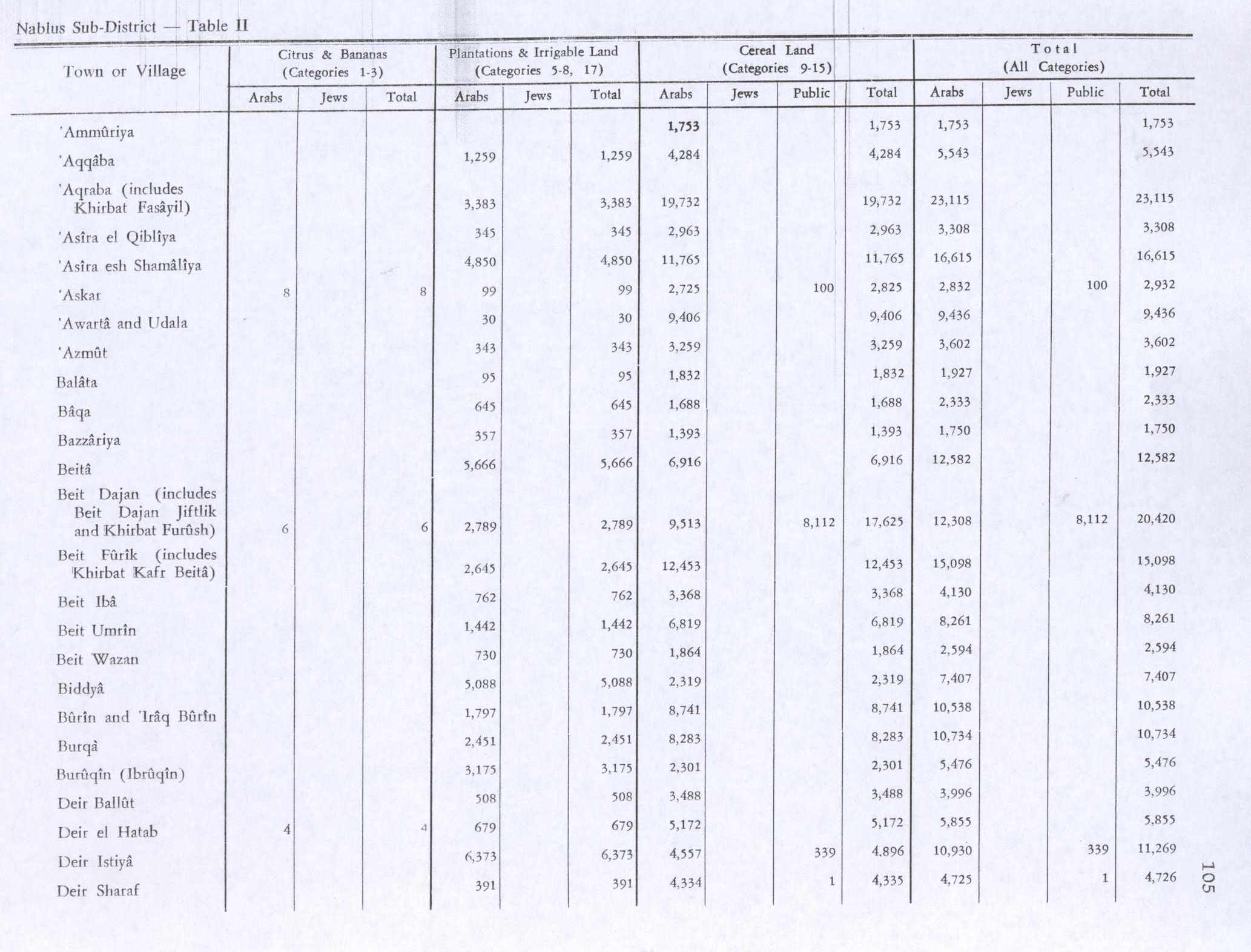
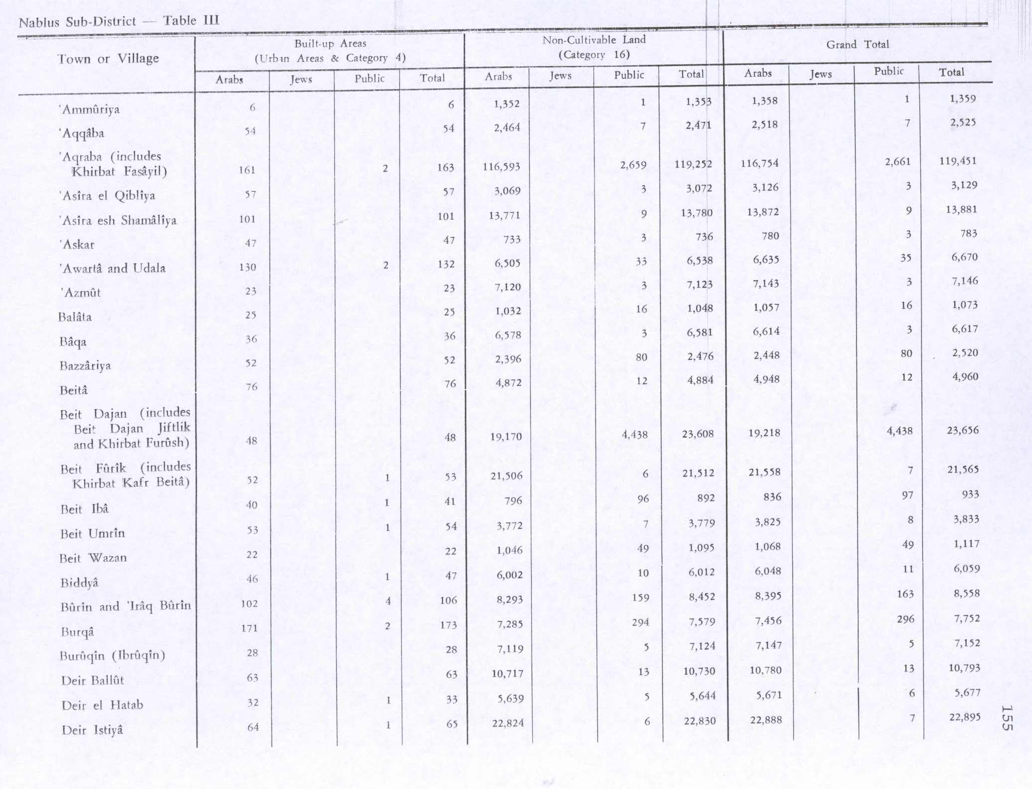
Of this, 5,088 were allocated for plantations and irrigable land, 2,319 for cereals, while 47 dunams were classified as built-up areas. File:Biddya 1941.jpg|Biddya 1941 1:20,000 File:Biddya 1945.jpg|Biddya 1945 1:250,000
Jordanian era
In the wake of the 1948 Arab–Israeli War, and after the 1949 Armistice Agreements, Biddya came under Jordanian rule. In 1961, the population of Biddya was 2,212.
Post-1967
Since the Six-Day War in 1967, Biddya has been under Israeli occupation. After the 1995 accords, 15.2% of village land was classified as Area B, the remaining 84.8% as Area C. The Israeli plans for the Israeli West Bank barrier will isolate and confiscate 1,943 dunums of the southern part of village land from Biddya. By mid-2012, according to Palestinian General Election Commission, Biddya's (بديا) population was 8,951 (not including expatriates).
Economy
Biddya depends primarily on olive groves for olive oil and Nabulsi soap production – the town's main industries. The town mostly receives food products from subsistence farming or local grocery markets.
Before the beginning of the Second Intifada in the fall of 2000, many residents worked in neighboring towns and cities, especially in Nablus and Ramallah, as well as for Israeli employers. The main road traversing the village, Road No. 505 (previously part of the Trans-Samaria Highway), was lined with many stores which served thousands of Israeli shoppers who would frequent the town each week, including residents of the Israeli settlements passing through, as well as Israelis living in the Tel Aviv area who were looking for products at low prices.
Unemployment was about 20%; however, since the Intifada that figure has risen to 78–90%. Besides farming, some inhabitants live off their savings and others receive aid from relatives abroad.
Public institutions
Biddya has five schools – two for each gender and a private school. Most high school graduates who attend college enroll in an-Najah National University in Nablus or Bir Zeit University in Bir Zeit. There are four mosques and three health clinics in the town.
See also
Killing of Aisha al-Rabi
External links
صورة لخارطة مدن فلسطين قبل النكبة + صور لبلدة بديا (www.PALDF.net) شبكة فلسطين للحوار Welcome To Biddya Biddya, Welcome to Palestine Survey of Western Palestine, Map 14: IAA, Wikimedia commons Biddya Town (Fact Sheet), Applied Research Institute–Jerusalem (ARIJ) Biddya Town Profile, ARIJ Biddya – aerial photo, ARIJ Development Priorities and Needs in Biddya, ARIJ
Text derived from https://en.wikipedia.org/w/index.php?oldid=1374139453 under CC BY-SA 4.0; modifications have been made.