Surif
≈ 4 min read
Names in other languages
No names in other languages are held for this entry yet.
Article bodies are English and are not machine-translated. A name in another language is not a translation of the article.
Surif ( ) is a Palestinian City in the Hebron Governorate located 25 km northwest of the city of Hebron. According to the Palestinian Central Bureau of Statistics census, Surif had a population of 17,287 in 2017. The population is entirely Muslim. Most of the town's 15,000 dunams is used for agriculture, in particular, olives, wheat and barley. The town has seven mosques and four schools. Ahmad Lafi is the mayor.
Surif ( ) is a Palestinian City in the Hebron Governorate located 25 km northwest of the city of Hebron. According to the Palestinian Central Bureau of Statistics census, Surif had a population of 17,287 in 2017. The population is entirely Muslim. Most of the town's 15,000 dunams is used for agriculture, in particular, olives, wheat and barley. The town has seven mosques and four schools. Ahmad Lafi is the mayor.
History
Ottoman period
Oral tradition suggests that Surif was founded after the 16th century. In 1838, Surif was described as a Muslim village between Hebron and Gaza under the administration of Hebron. By the nineteenth century, Ṣurīf and other Hebronite villages had extended their cultivation zones westward into the Shephelah, incorporating nearby ruined sites. This expansion reflected the combined effects of the Ottoman Land Code, local agricultural initiatives, and the stabilization of the region after the decline of Bedouin incursions. In 1863 Victor Guérin wrote that Surif had 700 inhabitants1. He further noted that beside a birket in the rock, a few cisterns and an ancient column shaft near a small mosque, all the construction was modern. An official Ottoman village list from about 1870 showed 87 houses and a population of 265, counting men only. In 1883, the PEF's Survey of Western Palestine described Surif as "A small village on a low hill, with olives to the south." In 1896 the population of Surif was 1,164.
British Mandate
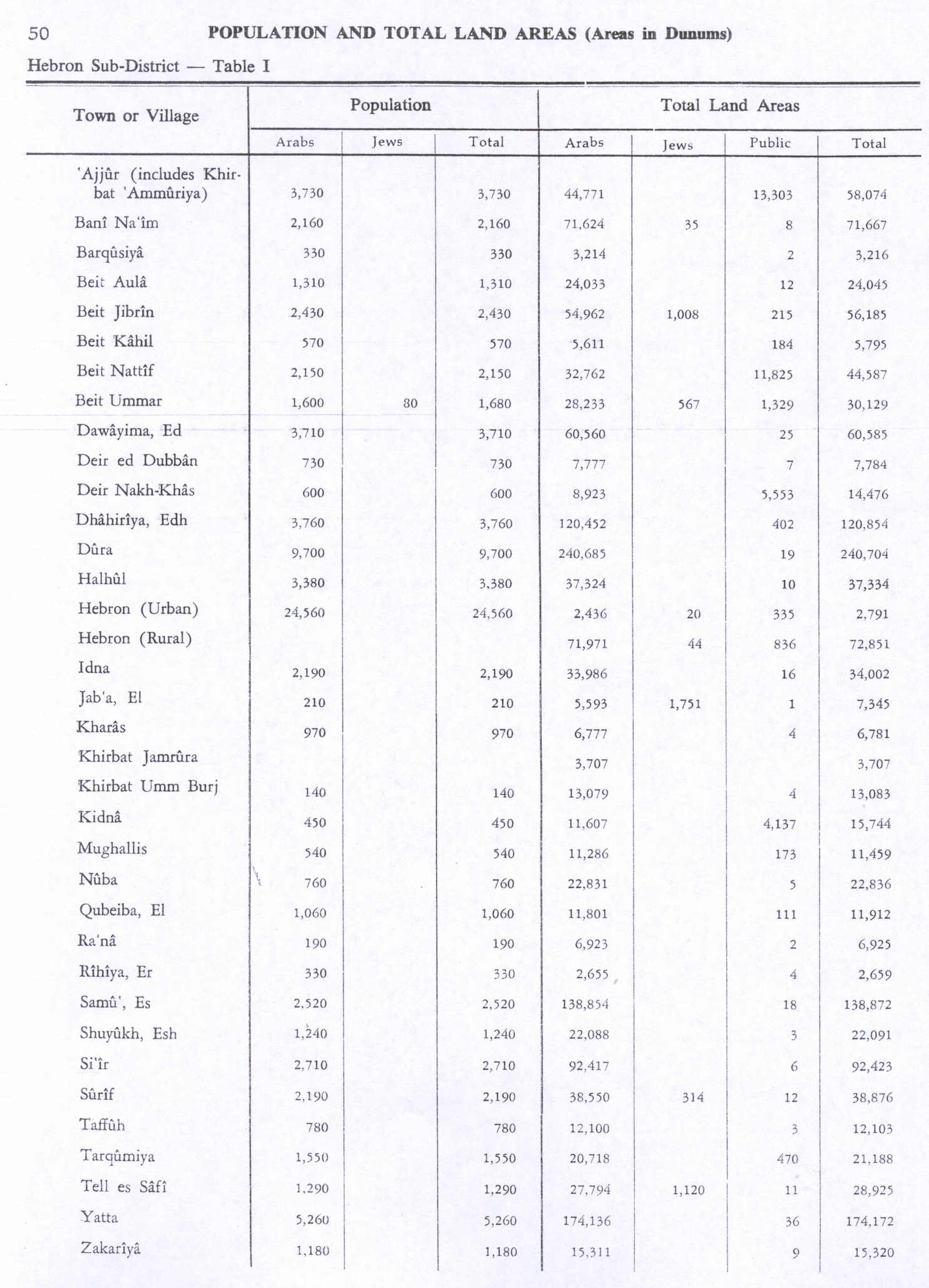
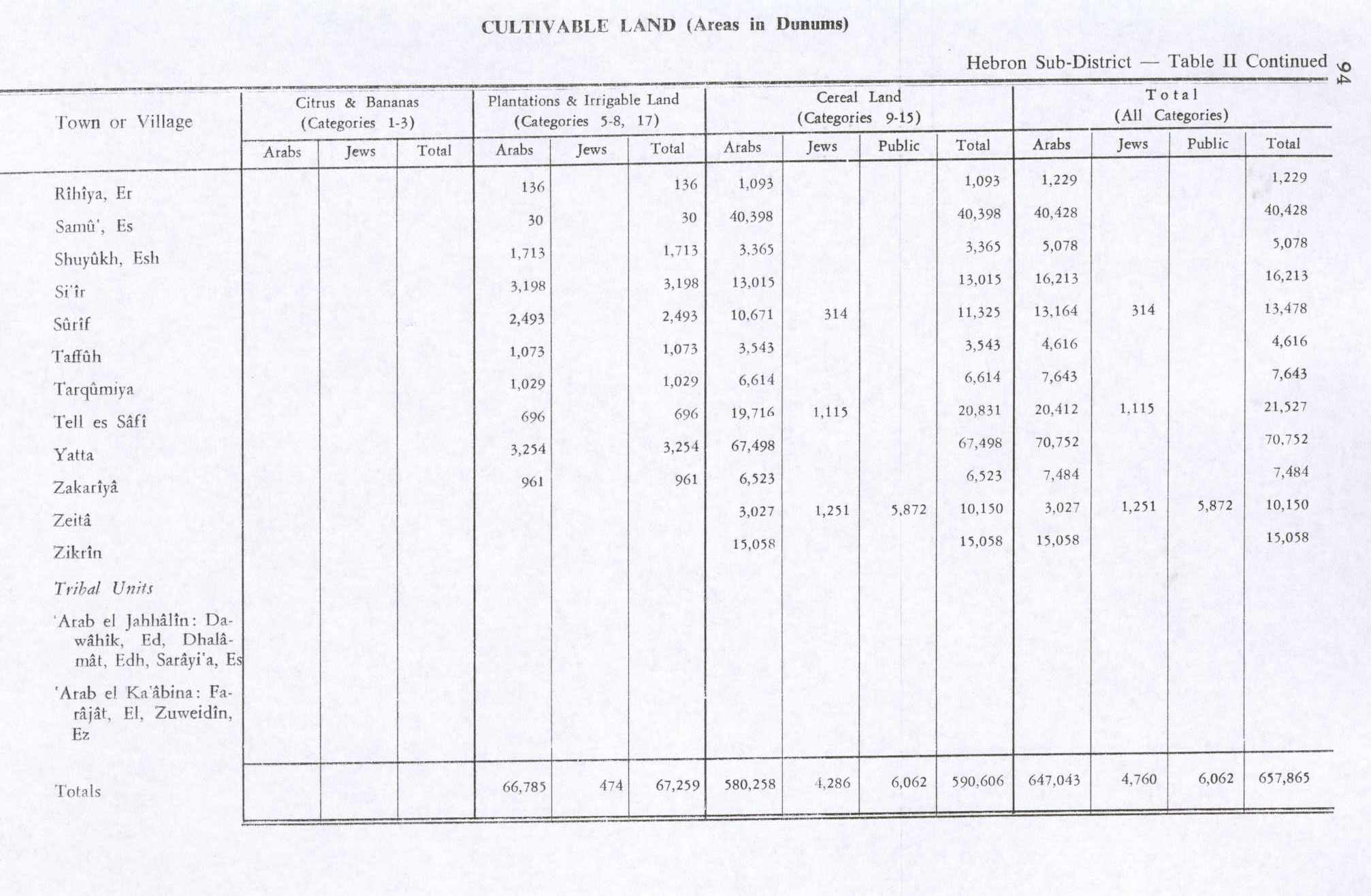
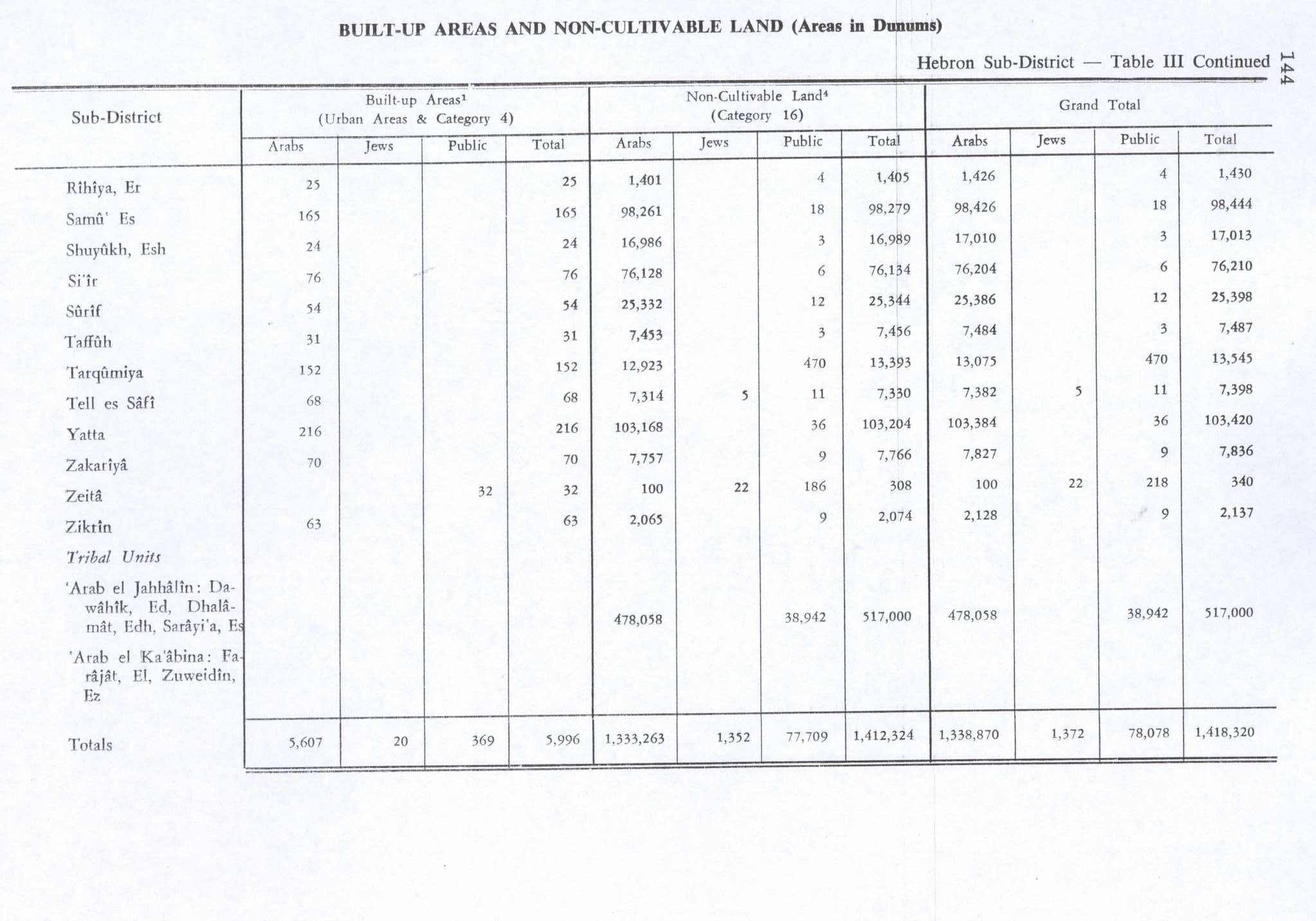
According to the 1922 census of Palestine conducted by the British Mandate authorities, Surif had a population of 1,265 inhabitants1, all Muslims, increasing in the 1931 census to 1,640, in 344 inhabited houses. In the 1945 statistics the population of Surif was 2,190, all Muslims, with a total of 38,876 dunams of land according to an official land and population survey. Of this, 3,493 dunams were plantations and irrigable land, 11.325 for cereals, while 54 dunams were built-up (urban) land. File:Surif 1944.jpg|Surif, British Mandate map, 1:20,000 File:Surif 1945.jpg|Surif 1945 1:250,000 File:Surif from Judean hills.jpg|View of Surif File:Surif cross-stitch.jpg|Example of traditional Palestinian cross-stitch from Surif (2006)
Jordanian rule
In the wake of the 1948 Arab–Israeli War and the 1949 Armistice Agreements, Surif came under Jordanian rule. The Jordanian census of 1961 found 2,827 inhabitants1 in Surif.
Post-1967
Since the Six-Day War in 1967, Surif has been under Israeli occupation. Israel has confiscated approximately 1,213 dunams of land from Surif since 2000, and approximately 1,300 dunums of Surif lands will be behind the Israeli West Bank barrier, when it is finished. In April 2023, the village was attacked for three days by dozens of settlers who broke into the village, injured residents with stones and vandalized and burned olive trees and residences. The attack by the settlers was carried out with the backing of an army that used gunfire and tear gas against residents who tried to defend themselves from the attackers. Since 2021, six cases of settler attacks have been documented, which included destruction of crops, damage to residences and injury to residents.
References
Bibliography
External links
Welcome To Surif Surif, Welcome to Palestine Survey of Western Palestine, Map 21: IAA, Wikimedia commons Surif Town (Fact Sheet), Applied Research Institute–Jerusalem, ARIJ Surif Town Profile, ARIJ Surif aerial photo, ARIJ The priorities and needs for development in Surif town based on the community and local authorities’ assessment, ARIJ
Text derived from https://en.wikipedia.org/w/index.php?oldid=1376934599 under CC BY-SA 4.0; modifications have been made.